Hey, Detour takers. You’re in the right place, or at least your ears are. You’re about to go on a unique audio adventure, experiencing the sounds and stories of Utica’s Bagg’s Square East. And along the way, we’ll be joined by a couple of the people who know this story best.

So here we go. It’s the perfect place to begin, because in a way, this is the spot where the city of Utica started, too.

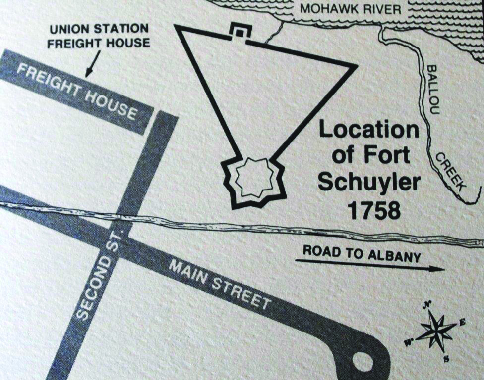
You’re at what is now a parking lot, just off second street, down near some railroad tracks. The tracks are in front of you, and right behind you is an old building with a big Charles Millar and Sons and Company sign painted on it. Now what you have to imagine is that it’s the 18th century and this is all wilderness.

The Mohawk River is running through about 50 feet on the other side of where those railroad tracks are now. There’s a trail made by Native Americans – the Iroquois – along the north bank of the river – you’re on the south bank now. And another Iroquois trail runs north-south right through where you’re standing. Now why here? Well the Mohawk River was running east along there, and coming down from the southern hills behind you was a creek, called Ballou Creek. It emptied into the Mohawk River about 50 feet right in front of us. Coming down from the northern hills in front of you into the Mohawk River was Reale’s Creek. And they both emptied their silt deposits into the river right here, which raised the riverbed and lowered the riverbanks. There was also a big curve in the river right here. Remember there are no highways or bridges at this time. Everything went though here on these trails. So the river is shallow, the current is slow, so what you have is a ford – f. o. r. d. – a place where you can cross the river on foot.

Well during the French and Indian War the British and French were fighting for control of North America, mostly for the lumber trade and fur trade. So in 1758 the British built a fort – f. o. r. t. – to guard the crossroads and the ford so they could control the area. The man in charge of building the fort was Colonel Peter Schuyler, so the fort was named after him – Fort Schuyler. This wasn’t a combat fort; it was more of a storage fort for troops and supplies going west. They had a huge pen for horses and oxen. And the fort was built in the shape of a triangle.


Behind you, that building that says Charles Millar and Son and Company on it. That’s where the peak of the triangle was, and the base of the fort ran along the river, down where the railroad tracks are. It was a pretty good sized fort.


Now around the same time the British built another fort where Rome is now, called Fort Stanwix. After the French and Indian War, the British abandoned both forts and they rotted after a few years. But during the American Revolution the colonists rebuilt Fort Stanwix, and named it after the ranking military man in the area, General Phillip Schuyler. He was the nephew of the man the fort here was named after. So to avoid confusion, this became known as Old Fort Schuyler. And after the revolution, people came west to settle, and a lot of them chose this area because of the good soil – in those days almost everybody was a farmer – and so the village that grew up around this spot became known as Old Fort Schuyler. And somewhere deep down below the concrete you’re standing on, there’s probably some remains of that original fort.

Alright now we’ll take a short walk up to the second stop on our Detour – the corner of Second Street and Main Streets.